Sunday, June 26, 2011

The Greatest Journey -- Out of the Outback

I always hate leaving the Outback whenever I travel in Australia. To me, it somehow seems like the end of the journey, no matter what lies ahead. It was today that Isabella and I would be re-entering so-called "Civilized Australia" but I couldn't help feel a pang of sadness as we drove, knowing that our adventures in the Outback were over.

After awaking and having a quick breakfast, Isabella and I continued south along the Stuart. The aboriginal people who had camped the night before had moved on. We encountered their convoy on the way south to Coober Pedy and we later learned that there was some important cultural gathering happening in the hills around Coober Pedy. We can only assume that that's where they were headed.

Along the road to Coober Pedy we stopped at an inconspicuous fence crossing the highway. It doesn't look important, much like any other boundary demarcating fence, but this one is special for 2 reasons: it crosses the highway (which is unusual) and it's part of the longest fence in the world. This is the famous Dingo Fence that stretches more than 5 000 kilometers from the Great Australian Bight to southern Queensland. It is about 2 000 kilometers longer than the Great Wall of China.

The Dingo Fence, or Dog Fence or Vermin Proof Fence, was built by pastoralists who wanted to protect their flocks from ravenous dingoes. On the south side of the fence there tend to be sheep but on the north side there tend to be cattle, which are too big for a dingo to tangle with. It continues to be maintained by farmers and does, at least to some extent, keep out the dingoes.

After our brief highway stop, Isabella and I continued to Coober Pedy. We stopped there and took a brief trip down the Oodnadatta Track, nothing more than a flattened dirt road, to where the Dingo Fence crosses that road. The weather-beaten sign says that the fence extends to Surfers Paradise in Queensland but I suspect that is for tourists. As far as I can tell, the fence ends in Jambour significantly further inland. I suppose statements written on signs aren't written under oath.

At this point there is also the Moon Plain, a barren featureless expansive void of rock. It is aptly named as standing alone on the Moon Plain gives a sense of complete desolation and isolation. If not for the Oodnadatta Track, no one would dare cross this place.

After leaving this harsh place, Isabella and I returned to the Stuart Highway and continued south. Along the way we stopped for lunch at Pimba, the roadside gas station that serves as an entrance to Woomera. It was here that I remembered why I liked eating in remote Australian locales --- the portions. I ordered a t-bone steak and even though the meal cost $22, the steak was quite large. It was something I had noticed when travelling in Tasmania as well. Having dined heartily, Isabella and I continued south towards Port Augusta, and somewhere along the way, though no one can say where exactly, we left the Outback.

We drove into Port Augusta in the early evening and decided to take a stroll around the town. There really wasn't much to it but Isabella had a guide book that gave a self-guided tour of the city. We walked by many old buildings and some places where buildings had one stood but had since been demolished. There were even the remains of an old ship near the harbour. We also walked by Port Augusta's landmark domed Town Hall but on closer inspection, it looked rather run down. Having seen a few photos of it, though from farther away, I thought the Town Hall would be better maintained but I guess times are hard in Port Augusta.

Isabella and I decided to camp in the Mount Remarkable National Park, a way to the south of Port Augusta. We decided to camp in the back area of the park, as had many others it seemed. I thought the most interesting part was that to pay for the night you take an envelope from the park entrance, put in the appropriate amount, fill in your vehicle details and then deposit it in a box at the entrance. This was all new to me but Isabella knew the procedure well as a park employee. We settled down for the night in our tent under a large tree. After some fairly exhausting days of driving, tomorrow's drive to Adelaide would be short and we'd have a chance to hike in the park.


Saturday, June 18, 2011

The Greatest Journey -- The Greatest Rock

Perhaps Australia's greatest geographic landmark is Uluru, formerly known as Ayers Rock. It is just so iconic of Australia and so unlike any other feature on Earth. To photograph it is unmistakeable proof that you were in Australia. Uluru sits in the heart of the Australian continent and the Australian psyche. For many aboriginal groups it is a symbol of their culture while all Australians in general have adopted it as a powerful symbol of their country.

Alice Springs and Uluru are so closely associated in most peoples' minds that few give a thought to how far apart the 2 actually are. Alice Springs is 460 kilometers away from Uluru; 200 kilometers down the Stuart Highway to Erldunda Roadhouse and then 260 kilometers down the Lasseter Highway. In order for us to see the rock, Isabella and I had to set out at 06:00. This was going to be our longest driving day and we had quite a site to see.

So we set off from Alice Springs along the road we had travelled only a few days before. As we headed south we sped along and made it to Erldunda in short order. I then steered the car onto the Lasseter and we continued towards the rock. The wonderful thing about the highway is that with so little traffic, you can really get some speed and on one occasion I even made it just past 180 km/h! So as we flew down the road we saw Mt. Conner to the south, a sort of mesa. We eventually reached the park gates and paid the $25/person entry fee and drove to the Visitors Centre. I had been here a few years before and Uluru hadn't changed much.

Inside the Visitors Centre were displays about the legends of Uluru and the customs of the local aboriginal people. Isabella and I walked around for a while before deciding on the base hike. There are several walks around Uluru, the longest being the base hike at about 16 kilometers. Although you can climb Uluru, the local aboriginals ask you to refrain as they feel it is disrespectful. Interestingly, though, the walk up is not forbidden because the traditional owners are worried that forbidding people to walk up would dramatically reduce tourism and revenues; the almighty dollar wins again. In any case, that walk was closed as the temperature was forecast to be 42C that day.

I parked the car close to the climbing spot and Isabella and I set out to walk around Uluru's base. This was around 11:00 and I was surprised to see that there were very few people around. Isabella later surmised that this was because of the heat and that most people had done the walk or climb earlier in the day. Anyway, the heat was bad enough but Isabella had a problem with the flies that seemed to flock around her. She eventually covered her face completely with scarves to keep out the flies but with enough space to get the tube from the water pack to her mouth; the picture is actually quite funny.

Walking around Uluru gives you a different perspective on the rock. You realize that it's more pockmarked than you first thought, that there are more rills and divots than pictures seem to show and it has an irregular shape. You can walk under shady overhangs, step up to rain water-filled pools on the base and tough the rock itself. You really get an appreciation for its size. It just seems to keep going and going. Along the way there are signs that tell the aboriginal myths about Uluru. How the serpent Kuniya took her revenge on those who had killed her nephew and the pockmarks where the spears had hit the rock. The geological story says that Uluru is a large monolith, a single piece of rock, that is part of a larger subterranean feature. It was once part of the bottom of a large, shallow sea. Whatever you believe, Uluru is a unique place and really walking around it gives you the best view.

As Isabella and I marched on in the oppressive heat we stopped to take photos of what we could, as not everything can be photographed, in keeping with aboriginal custom. We saw where large chunks of rock had hewn themselves free from Uluru. We even saw some aboriginal rock art. Then, thirsty and tired from our 3-hour walk in the noon-day sun in high summer, Isabella and I returned to our car which, surprisingly, was not that hot on the inside.

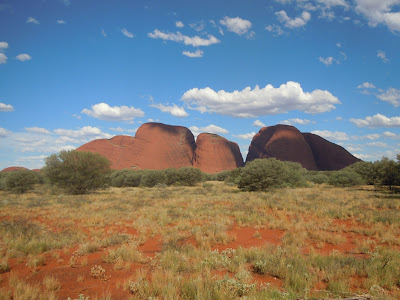
From Uluru we drove to Kata Tjuta, formerly called the Olgas, another rock formation less than 50 kilometers away. It is composed of several dome-like structures and you can walk in between them. Isabella and I decided that we only had time to walk up to the base of the walk but we had a good time nonetheless.

I was glad I showed Isabella these features, especially Uluru. It would have been a great shame if she hadn't seen it while being relatively so close. We then sped back along the Lasseter before heading down the Stuart back south towards Coober Pedy.

As the sun set it became clear that we would have to camp for the night. About 110 kilometers north of Coober Pedy we reached one of the featured rest stops in our atlas. As we turned in we noticed a very large number of 4WD vehicles and aboriginal people. At first we were concerned that there wouldn't be enough room for us but as we drove further into the rest stop, it seemed as though the aboriginals were camping only fairly close to the road. We thought that a little strange but we parked in the quiet rest area where there were only a few other vehicles. We set up the tent, had a quick late dinner and the headed off to sleep. By tomorrow we'd be out of the Outback and ending that part of our adventure.


Friday, June 17, 2011

The Greatest Journey -- Just Deserts

For our final day in Alice Springs, Isabella and I decided to visit an attraction that Bill Bryson had himself visited when he was in Alice Springs --- the Desert Park. While it may seem a little counterintuitive to recreate a desert in a desert, it's actually very informative. The park recreates 3 forms of desert, each defined by the amount of rainfall it reserves, and uses native flora and fauna, particularly birds. As a parks interpreter, as she calls it, I thought Isabella would find this particularly interesting and I think we both had a great time.

One of the features of the park is its interpretive talks. At certain times of the day various staff members give talks on, for example, how aboriginal people survived in days gone by, birds of prey, various desert reptiles and the desert's nocturnal animals. A short time after we arrived, there was a talk on aboriginal bush food ("tucker" in Aussie). Many plants were edible as were Widgetty grubs. The talk was very informative and gave everyone a better insight into how aboriginal people used to live. The staff member brought out all sorts of edible plans, decorative ochre and everyday tools for people to see. She also explained how aboriginal people found water and the complex nature of aboriginal society. I noted how aboriginals in Australia and Canada had devised very similar solutions to their problems. Isabella, having some knowledge of Canadian aboriginal culture, already knew what some of the herbs were used for even before the interpreter had finished explaining.

From there we wandered around the park. The Desert Park is rather large and getting around in the sun wasn't very easy. We walked around the various sections, seeing what salt and clay pans are like and the various birds that inhabit the ecosystems. There were even some enclosed sanctuaries with some very colourful birds.

At on point we went into the nocturnal animal enclosure and were the only ones there for the scheduled talk. This was in stark contrast to the aboriginal bush tucker talk that had been attended by 20-30 people. Anyway, the staff member took as around the displays and showed us the desert's various nocturnal inhabitants. There were trap door spiders, scorpions that glowed under UV light and the elusive bilby. There were also nocturnal birds like the Tawny Frogmouth. There were even some Thorny Devils and large snakes in glass enclosures.

From the nocturnal enclosures, Australia wandered around some more. We eventually made our way to the star attraction of the Desert Park --- the bird of prey show. This particular show involves various trained birds of prey showing off their various flying and hunting skills. There used to be a Wedge-tailed Eagle but he kept getting in fights with the wild ones that lived in the surrounding hills so they had to abandon that one. Still, the show went on with an owl, a kite and a hawk. The staff member, who had a very thick New Zealand accent, did a wonderful job of explaining how each bird flies and hunts. For example, the owl has a silent flight so it can swoop on its prey unsuspectingly. The kite, I believe, can move things from its talons to its mouth in flight. I managed to snap some pictures of the hawk just as it scooped up its food. For his first time, the staff member did very well.

Although it doesn't sound like we did a lot, the Desert Park took up the entire day. Isabella and I drove home excited because the next day we were hitting the road again, and very early at that. We had too because we had a lot of ground to cover, including a trip to Australia's most beloved boulder.