Alice Springs and Uluru are so closely associated in most peoples' minds that few give a thought to how far apart the 2 actually are. Alice Springs is 460 kilometers away from Uluru; 200 kilometers down the Stuart Highway to Erldunda Roadhouse and then 260 kilometers down the Lasseter Highway. In order for us to see the rock, Isabella and I had to set out at 06:00. This was going to be our longest driving day and we had quite a site to see.
So we set off from Alice Springs along the road we had travelled only a few days before. As we headed south we sped along and made it to Erldunda in short order. I then steered the car onto the Lasseter and we continued towards the rock. The wonderful thing about the highway is that with so little traffic, you can really get some speed and on one occasion I even made it just past 180 km/h! So as we flew down the road we saw Mt. Conner to the south, a sort of mesa. We eventually reached the park gates and paid the $25/person entry fee and drove to the Visitors Centre. I had been here a few years before and Uluru hadn't changed much.
Inside the Visitors Centre were displays about the legends of Uluru and the customs of the local aboriginal people. Isabella and I walked around for a while before deciding on the base hike. There are several walks around Uluru, the longest being the base hike at about 16 kilometers. Although you can climb Uluru, the local aboriginals ask you to refrain as they feel it is disrespectful. Interestingly, though, the walk up is not forbidden because the traditional owners are worried that forbidding people to walk up would dramatically reduce tourism and revenues; the almighty dollar wins again. In any case, that walk was closed as the temperature was forecast to be 42C that day.
I parked the car close to the climbing spot and Isabella and I set out to walk around Uluru's base. This was around 11:00 and I was surprised to see that there were very few people around. Isabella later surmised that this was because of the heat and that most people had done the walk or climb earlier in the day. Anyway, the heat was bad enough but Isabella had a problem with the flies that seemed to flock around her. She eventually covered her face completely with scarves to keep out the flies but with enough space to get the tube from the water pack to her mouth; the picture is actually quite funny.
Walking around Uluru gives you a different perspective on the rock. You realize that it's more pockmarked than you first thought, that there are more rills and divots than pictures seem to show and it has an irregular shape. You can walk under shady overhangs, step up to rain water-filled pools on the base and tough the rock itself. You really get an appreciation for its size. It just seems to keep going and going. Along the way there are signs that tell the aboriginal myths about Uluru. How the serpent Kuniya took her revenge on those who had killed her nephew and the pockmarks where the spears had hit the rock. The geological story says that Uluru is a large monolith, a single piece of rock, that is part of a larger subterranean feature. It was once part of the bottom of a large, shallow sea. Whatever you believe, Uluru is a unique place and really walking around it gives you the best view.
As Isabella and I marched on in the oppressive heat we stopped to take photos of what we could, as not everything can be photographed, in keeping with aboriginal custom. We saw where large chunks of rock had hewn themselves free from Uluru. We even saw some aboriginal rock art. Then, thirsty and tired from our 3-hour walk in the noon-day sun in high summer, Isabella and I returned to our car which, surprisingly, was not that hot on the inside.
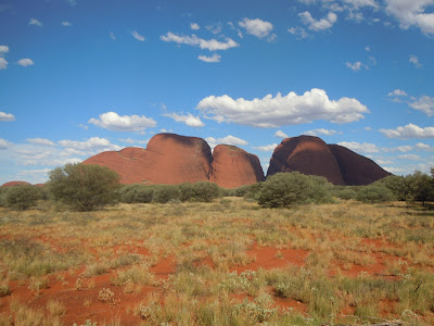
From Uluru we drove to Kata Tjuta, formerly called the Olgas, another rock formation less than 50 kilometers away. It is composed of several dome-like structures and you can walk in between them. Isabella and I decided that we only had time to walk up to the base of the walk but we had a good time nonetheless.
I was glad I showed Isabella these features, especially Uluru. It would have been a great shame if she hadn't seen it while being relatively so close. We then sped back along the Lasseter before heading down the Stuart back south towards Coober Pedy.
As the sun set it became clear that we would have to camp for the night. About 110 kilometers north of Coober Pedy we reached one of the featured rest stops in our atlas. As we turned in we noticed a very large number of 4WD vehicles and aboriginal people. At first we were concerned that there wouldn't be enough room for us but as we drove further into the rest stop, it seemed as though the aboriginals were camping only fairly close to the road. We thought that a little strange but we parked in the quiet rest area where there were only a few other vehicles. We set up the tent, had a quick late dinner and the headed off to sleep. By tomorrow we'd be out of the Outback and ending that part of our adventure.


No comments:
Post a Comment