The south coast from Dunedin to Invercargill is quite ruggedly spectacular and has been given the name, The Catlins. It is sparsely populated but has some very interesting things to see. I'm trying to think of an equivalent place in North America but I can't; perhaps something like the south California coast if it were transported to the eastern seaboard. At any rate, Isabella and I decided to try this area next.
Our first stop was actually at the semi-rural house of some people Isabella had met earlier in her travels. They lived in a house on the hills overlooking Dunedin and the view of the city was very good. Isabella's friend, whose name I now forget, lives a sort of bohemian existence with her partner. There are 2 couples, I believe, and they share this one, reasonably big house. As I mentioned it's just outside Dunedin and it didn't take us long to get there. Isabella and her friend chatted for quite some time and I joined in when I could and we stayed about an hour, maybe. Afterwards, we drove back through Dunedin and to the south towards the Catlins.
To get to the Catlins you have to drive along the main highway before turning off at Balclutha. I remember there being quite a lot of construction on the roads which made them rough and slowed down traffic. I don't know if this was because of the earthquake a little while before or if it was simply seasonal work that had to be done. We eventually reached the turnoff and headed down the road network known as the Southern Scenic Route. This is not a major highway, you have to understand, but country roads. There was still a fair bit of traffic but you could tell that the Catlins, while certainly well-visited, were probably often overlooked by travellers who merely wished to get to Invercargill or Dunedin.
Our first stop was Kaka Point where, like Sandfly Bay the day before, we took to hiding behind a blind to see hoihos. There were a few in the grass on the hills. It seems that hoihos go to great lengths to set their nests in the grass where the eggs will be safer from predators.
Our next stop was nearby Nugget Point with its famous lighthouse. Here there were quite a number of people milling about and it seemed to be one of the more popular spots. It was a bit of a walk from the parking lot to the actual lighthouse but the view from was quite lovely. The The coastline on either side of the lighthouse is quite rugged and has no doubt claimed many vessels in its time. The day had been quite sunny up to this point but as we left Nugget Point, the clouds were truly coming and it was clear we would be in for some wet weather. This is not unexpected and this part of the South Island is prone to such changes as there really is nothing between it and Antarctica so cold, wet weather is a feature of existence here.
From Nugget Point we drove to Purakaunui Falls, a smallish waterfall in the area. The roads to the falls were paved but mostly through woods and I don't recall there being any other cars really. We made it to the falls, parked the car and walked down. The falls were quite nice, a series of cascades in the forest but nothing truly spectacular.
From there we drove to Niagara Falls. This drive took us along some very hilly terrain but it did offer some great views of the area. We had noticed the name on one of the maps we had and decided to check it out as our Canadian heritage impelled us. Niagara Falls, in this case, is a small rapid and the person who named them after the famous North American falls did so expressly out of irony.
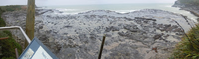
From Niagara Falls we drove along the coast to Curio Bay which has a famous petrified forest. The rain was coming down hard now and reminded me of the last time I was in Invercargill. The petrified forest sits on a sort of rocky shelf right on the ocean and you can step out onto it. Although it was raining quite hard, I decided to take a walk on the rocks. At various points you could see what were once trees and they had now hardened to solid rock. It was actually quite informative and there were 2 volunteer conservation officers who explained various things.
Our last stop for the day was Slope Point, the South Island's southernmost point, and here were truly alone. There not another car on the whole road there and when Isabella and I exited, there was hardly a sound. The walk down to the point goes through a farmer's field but I imagine there is a public right of way, at least, no one came out and told us to get off their land. Slope Point itself is just a rocky outcrop that juts into the sea. I went right to the edge and thought that this was the last point of land between here and the Antarctic ice, over 4 000 kilometers away. From Slope Point though, in the distance, through the sun's rays, you could just make out Rakiura (Stewart Island) and the rugged coastline extending to Invercargill.
Isabella and I climbed back into the car for the trip back and this is where the harrowing part of our journey began. We made it to the village of Fortrose which marks the end of the Catlins. I had intended to skip Invercargill altogether and simply head north towards Edendale where we could meet up with Highway 1, the principal route in the south part. I noticed we were a little low on gas but decided to press on and fill in Edendale. Unfortunately as we followed the signs to Edendale we were going through back country roads that while paved, had few settlements about them. Luckily there were signs to Edendale until we hit a crossroads and the sign only pointed to Wyndham. I decided to turn in the opposite direction, which turned out to be a mistake. I later saw on Google Street View that I should've turned towards Wyndham and we would've reached Edendale quite quickly.
As it was , our current situation was that we were lost along country roads, low on fuel, in the dead of night, but heading towards Invercargill. We could only hope that we would reach that city before our fuel ran out. As it turned out, after making our way long these country roads and through back streets, we reached Invercargill and found a gas station. I apologized to Isabella as profusely as I could for our situation but promised to make up for it by taking here to the Lone Star, a steakhouse my brother and I had gone to when we were in Invercargill. Luckily it was still open and we had a very good meal, including some wonderful deep-fried Bluff oysters. These oysters are farmed in Bluff, only 30 kilometers to the south and are known for their taste. I who generally am apprehensive of seafood had a taste and they appealed to me.
After this rather late dinner, I took Isabella to Invercargill's famous water tower. It was lit up and we drove around it. After getting a little lost in the city we managed to find our way back onto the principal highway and raced back towards Dunedin, which is only 200 and a bit kilometers away. Isabella slept most of the way for which I cannot blame her. We passed through some towns and villages but all over there was quite and very few other cars on the road. With so little traffic it was easy to make it to Dunedin and when we finally reached our hostel, we crawled up and fell asleep as soon as we could.


Our first stop was actually at the semi-rural house of some people Isabella had met earlier in her travels. They lived in a house on the hills overlooking Dunedin and the view of the city was very good. Isabella's friend, whose name I now forget, lives a sort of bohemian existence with her partner. There are 2 couples, I believe, and they share this one, reasonably big house. As I mentioned it's just outside Dunedin and it didn't take us long to get there. Isabella and her friend chatted for quite some time and I joined in when I could and we stayed about an hour, maybe. Afterwards, we drove back through Dunedin and to the south towards the Catlins.
To get to the Catlins you have to drive along the main highway before turning off at Balclutha. I remember there being quite a lot of construction on the roads which made them rough and slowed down traffic. I don't know if this was because of the earthquake a little while before or if it was simply seasonal work that had to be done. We eventually reached the turnoff and headed down the road network known as the Southern Scenic Route. This is not a major highway, you have to understand, but country roads. There was still a fair bit of traffic but you could tell that the Catlins, while certainly well-visited, were probably often overlooked by travellers who merely wished to get to Invercargill or Dunedin.
Our first stop was Kaka Point where, like Sandfly Bay the day before, we took to hiding behind a blind to see hoihos. There were a few in the grass on the hills. It seems that hoihos go to great lengths to set their nests in the grass where the eggs will be safer from predators.
Our next stop was nearby Nugget Point with its famous lighthouse. Here there were quite a number of people milling about and it seemed to be one of the more popular spots. It was a bit of a walk from the parking lot to the actual lighthouse but the view from was quite lovely. The The coastline on either side of the lighthouse is quite rugged and has no doubt claimed many vessels in its time. The day had been quite sunny up to this point but as we left Nugget Point, the clouds were truly coming and it was clear we would be in for some wet weather. This is not unexpected and this part of the South Island is prone to such changes as there really is nothing between it and Antarctica so cold, wet weather is a feature of existence here.
From Nugget Point we drove to Purakaunui Falls, a smallish waterfall in the area. The roads to the falls were paved but mostly through woods and I don't recall there being any other cars really. We made it to the falls, parked the car and walked down. The falls were quite nice, a series of cascades in the forest but nothing truly spectacular.
From there we drove to Niagara Falls. This drive took us along some very hilly terrain but it did offer some great views of the area. We had noticed the name on one of the maps we had and decided to check it out as our Canadian heritage impelled us. Niagara Falls, in this case, is a small rapid and the person who named them after the famous North American falls did so expressly out of irony.
From Niagara Falls we drove along the coast to Curio Bay which has a famous petrified forest. The rain was coming down hard now and reminded me of the last time I was in Invercargill. The petrified forest sits on a sort of rocky shelf right on the ocean and you can step out onto it. Although it was raining quite hard, I decided to take a walk on the rocks. At various points you could see what were once trees and they had now hardened to solid rock. It was actually quite informative and there were 2 volunteer conservation officers who explained various things.
Our last stop for the day was Slope Point, the South Island's southernmost point, and here were truly alone. There not another car on the whole road there and when Isabella and I exited, there was hardly a sound. The walk down to the point goes through a farmer's field but I imagine there is a public right of way, at least, no one came out and told us to get off their land. Slope Point itself is just a rocky outcrop that juts into the sea. I went right to the edge and thought that this was the last point of land between here and the Antarctic ice, over 4 000 kilometers away. From Slope Point though, in the distance, through the sun's rays, you could just make out Rakiura (Stewart Island) and the rugged coastline extending to Invercargill.
Isabella and I climbed back into the car for the trip back and this is where the harrowing part of our journey began. We made it to the village of Fortrose which marks the end of the Catlins. I had intended to skip Invercargill altogether and simply head north towards Edendale where we could meet up with Highway 1, the principal route in the south part. I noticed we were a little low on gas but decided to press on and fill in Edendale. Unfortunately as we followed the signs to Edendale we were going through back country roads that while paved, had few settlements about them. Luckily there were signs to Edendale until we hit a crossroads and the sign only pointed to Wyndham. I decided to turn in the opposite direction, which turned out to be a mistake. I later saw on Google Street View that I should've turned towards Wyndham and we would've reached Edendale quite quickly.
As it was , our current situation was that we were lost along country roads, low on fuel, in the dead of night, but heading towards Invercargill. We could only hope that we would reach that city before our fuel ran out. As it turned out, after making our way long these country roads and through back streets, we reached Invercargill and found a gas station. I apologized to Isabella as profusely as I could for our situation but promised to make up for it by taking here to the Lone Star, a steakhouse my brother and I had gone to when we were in Invercargill. Luckily it was still open and we had a very good meal, including some wonderful deep-fried Bluff oysters. These oysters are farmed in Bluff, only 30 kilometers to the south and are known for their taste. I who generally am apprehensive of seafood had a taste and they appealed to me.
After this rather late dinner, I took Isabella to Invercargill's famous water tower. It was lit up and we drove around it. After getting a little lost in the city we managed to find our way back onto the principal highway and raced back towards Dunedin, which is only 200 and a bit kilometers away. Isabella slept most of the way for which I cannot blame her. We passed through some towns and villages but all over there was quite and very few other cars on the road. With so little traffic it was easy to make it to Dunedin and when we finally reached our hostel, we crawled up and fell asleep as soon as we could.


No comments:
Post a Comment